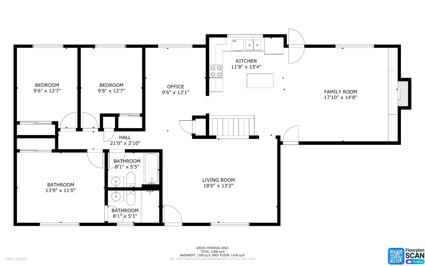
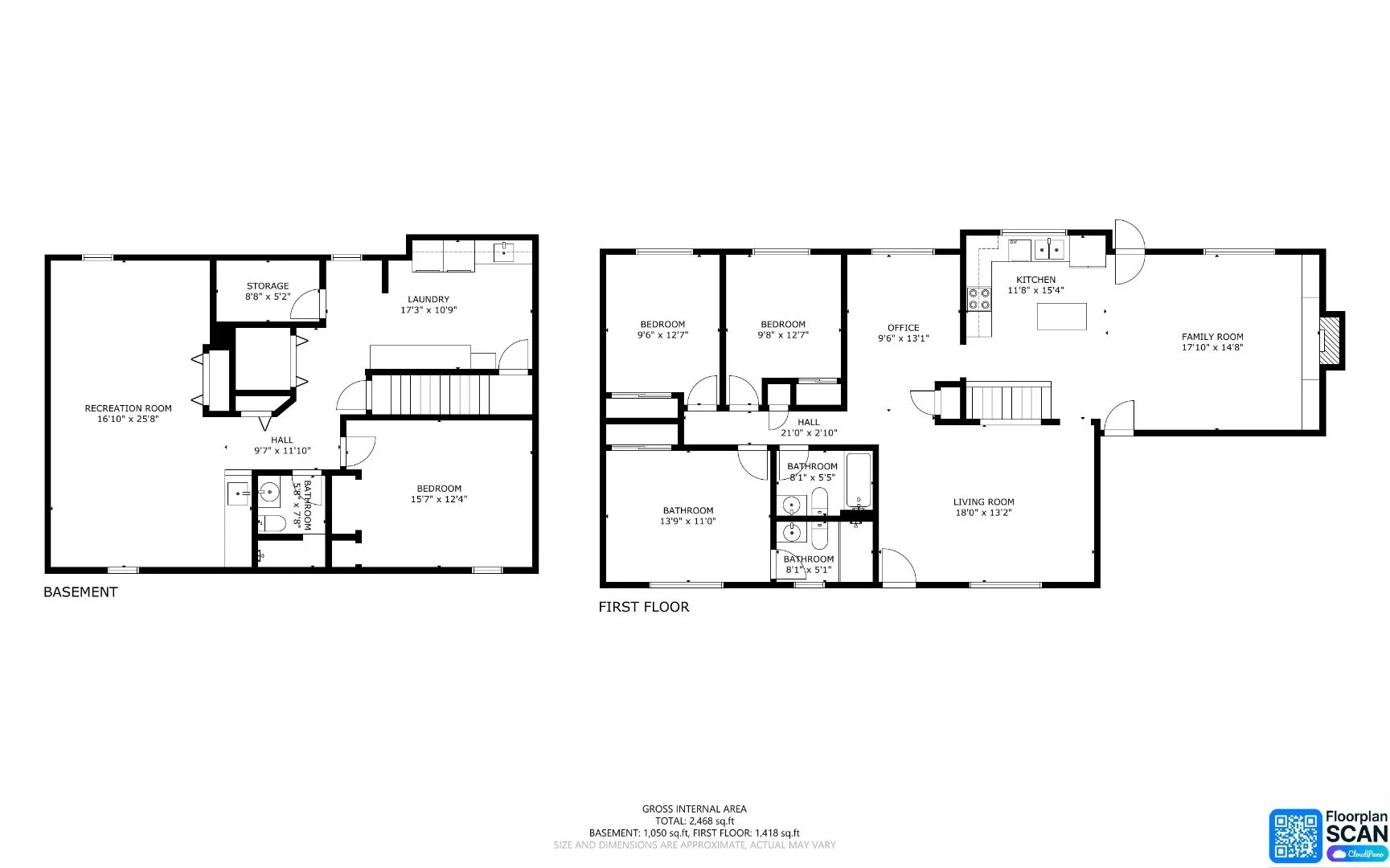
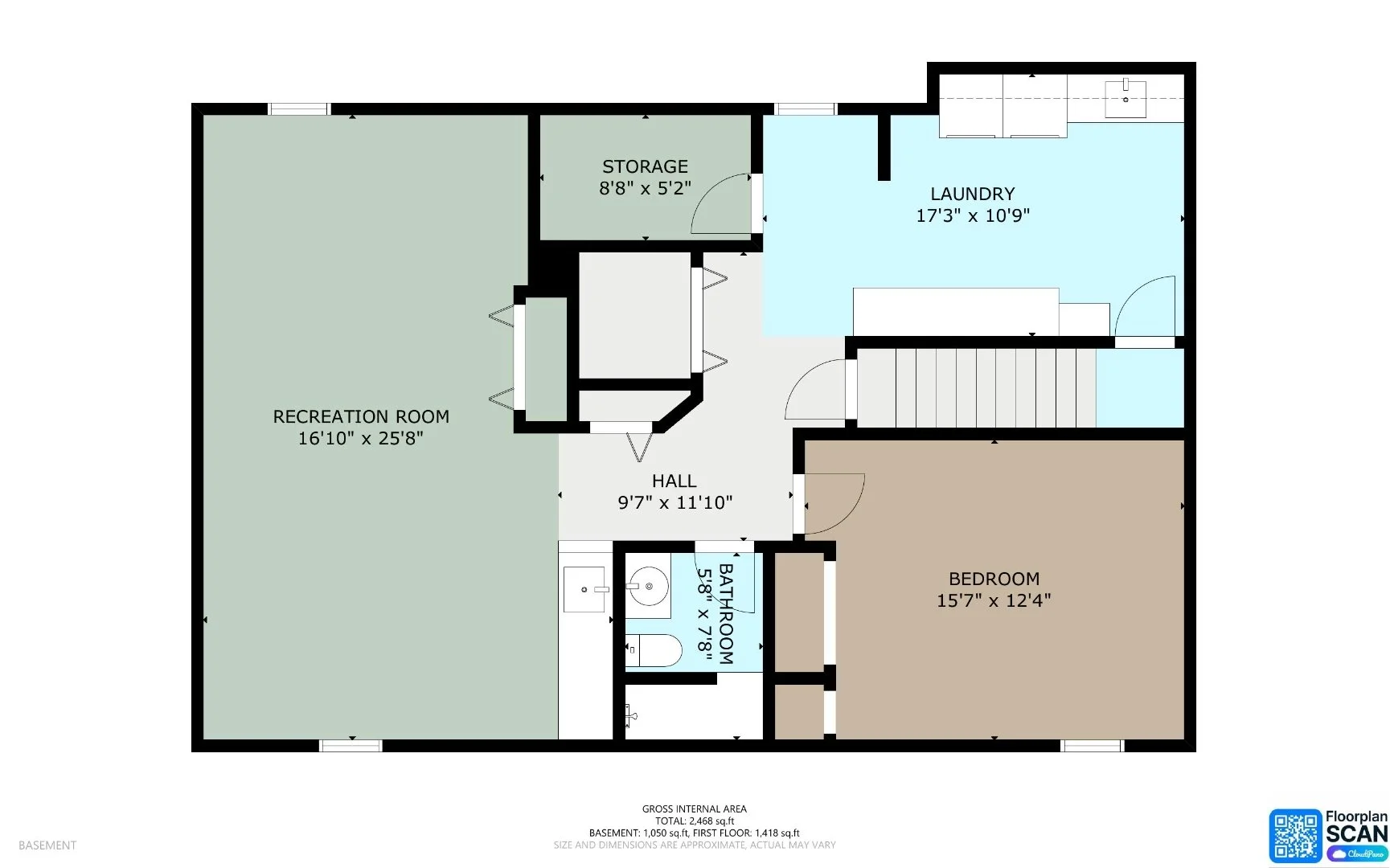
Drone & Photography Services for Real Estate, Commercial Properties & Mapping Projects

Condor Drone & Photography Services provides professional real estate photography, aerial imaging, commercial drone photography, drone video, 3D virtual tours, mapping imagery, and site documentation across Parker, Denver, Castle Rock, Colorado Springs, Fort Collins, and the Colorado Front Range.

Whether you need polished listing media, aerial marketing visuals, construction progress documentation, or drone mapping support, we help turn properties and project sites into clear, professional visual deliverables.

Real Estate Media Services

Full-service real estate photography for agents, property managers, builders, homeowners, and short-term rental hosts who need clean, listing-ready media that helps properties stand out.

Residential Listing Photography

Professional interior and exterior photos for homes, condos, townhomes, rentals, investment properties, and short-term rental listings.

Learn more →

Aerial Real Estate Photography

Drone photos and video that show location, lot size, surrounding area, views, access, landscaping, and the full exterior story of the property.

Learn more →

3D Tours & Virtual Walkthroughs

Interactive virtual tour options for residential listings, rental properties, and spaces where buyers or guests need a better feel for the layout.

Learn more →

Listing Video

Short, clean property videos for websites, MLS marketing, social media, agent branding, and client presentations.

Learn more →

Floor Plans

Optional floor plan add-ons to help buyers understand flow, room relationships, and overall property layout.

Ask about floor plans →

Airbnb & Rental Media

Interior, exterior, amenity, and aerial images for short-term rentals, property managers, and vacation rental listings.

Request rental media →

Commercial & Technical Drone Services

Aerial photography, drone video, mapping imagery, and visual site documentation for commercial real estate, construction, land, development, inspections, and business marketing projects.

Commercial Property Drone Photography

Aerial photos and video for commercial real estate, retail centers, office buildings, industrial sites, business parks, and investment properties.

Learn more →

Drone Mapping & Orthomosaic Imaging

RTK-enabled drone capture, orthomosaic-style imagery, and aerial mapping support for land, construction, development, and site documentation.

Learn more →

Construction Progress Documentation

Repeatable aerial photo and video capture for project milestones, stakeholder updates, before-and-after comparisons, and construction records.

Learn more →

Vacant Land & Acreage Marketing

Drone photos, video, and contextual views that help buyers understand land layout, access roads, surroundings, terrain, and property potential.

Learn more →

Roof & Property Inspections

High-resolution aerial imagery for roof condition documentation, exterior property review, insurance records, and hard-to-see areas.

Learn more →

Business & Social Media Content

Short-form drone video, exterior visuals, behind-the-scenes project footage, and promotional media for websites and social channels.

Request content package →

One Business, Two Clear Service Paths

Some clients need polished listing photos. Others need commercial aerials, mapping imagery, or construction documentation. Condor Drone & Photography Services brings both sides together: professional photography for real estate and practical drone services for commercial, technical, and outdoor projects.

This makes us a strong fit for realtors, builders, developers, landscapers, property managers, investors, local businesses, and landowners who need reliable visual media without bouncing between multiple vendors.

Common Projects We Handle

We can tailor the shoot around the property, the intended use, the required deliverables, and the timeline.

  • Residential real estate listings
  • Commercial real estate marketing
  • Retail centers and storefronts
  • Vacant land and acreage listings
  • Construction and landscape progress updates
  • Drone mapping and orthomosaic imagery
  • Short-term rental and Airbnb media
  • Roof and exterior property documentation
  • Business website and social media content
  • Before-and-after project documentation

How the Process Works

Tell Us About the Property or Project

Send the address, project type, desired media, timeline, and any must-have shots or deliverables.

We Recommend the Right Package

We help match the job to the right service level, whether that is a basic photo set, drone add-on, commercial package, video, mapping capture, or repeat progress visits.

Professional Capture

We complete the shoot using professional photography and drone equipment, with attention to safety, airspace, lighting, angles, and your project goals.

Edited Digital Delivery

Final images and videos are edited for clean presentation and delivered digitally for use in listings, websites, social media, marketing, documentation, or project review.

Services FAQs

Do you provide full-service real estate photography in Colorado?

Yes. Condor Drone & Photography Services provides full-service real estate photography in Parker and across the Colorado Front Range, including interior photos, exterior photos, drone photos, video, 3D virtual tours, and listing media add-ons.

Do you offer commercial drone photography and videography?

Yes. We provide aerial photography and drone videography for commercial properties, retail centers, office buildings, construction sites, land developments, and business properties throughout the Colorado Front Range.

Do you offer drone mapping or orthomosaic imaging?

Yes. We offer RTK-enabled drone capture, orthomosaic-style imagery, aerial mapping support, and site documentation for land, construction, development, real estate, and property projects. Formal legal surveys should be completed by a licensed surveyor.

What areas do you serve?

We are based near Parker, Colorado and serve Denver, Aurora, Castle Rock, Centennial, Highlands Ranch, Littleton, Colorado Springs, Fort Collins, Loveland, Boulder, and other areas across the Colorado Front Range.

How do I know which service I need?

Send us the property address, project type, timeline, and what you need the final media to accomplish. We can recommend a practical option based on whether the project is for listing media, commercial marketing, mapping, documentation, or progress updates.

Ready to Plan a Shoot?

Tell us what you are working on and what you need to show. We will help you choose the right photography, drone, video, or mapping option for your project.

Request a Quote

Standard Packages

Below are some of our most common packages. They help make real estate or commercial choices easier. Of course we can customize any of these based on your needs. Other services may require a consultation to better understand your needs and to get you the best priced quote possible.

Contact us

Interested in working together? Fill out some info and we will be in touch shortly. We can’t wait to hear from you!